GIS Search Tab Fields
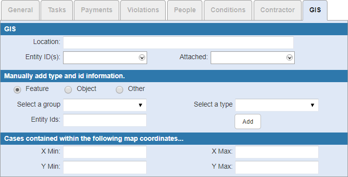
GIS Section Fields
- Location: Enter the location.
- Entity ID(s): Select an entity from the map.
- Attached: Select Y if an entity is attached.
Manually Add Type and ID Information Section Fields
- Feature: Select if the asset is a feature.
- Object: Select if the asset is an object.
- Other: Select if the asset is different than a feature and an object.
- Select a group: Select the entity group, such as water, sewer, or storm.
- Select a type: Select the entity type based on the entity group. For example, if you select Water for the entity group, then the entity type may populate with features such as fire hydrant maintenance or water mains.
- Entity Ids: Enter the ID of the entity.
- Add: Click to manually add the entity information to the GIS section.
Cases Contained Within the Following Map Coordinates Section Fields
- X Min: Enter the minimum X coordinate.
- X Max: Enter the maximum X coordinate.
- Y Min: Enter the minimum Y coordinate.
- Y Max: Enter the maximum Y coordinate.

Documentation Feedback Form
Please give us feedback about this Cityworks guide.
If you have a feature enhancement request, please see the Ideas page on MyCityworks.
Last updated 4/9/2019.
Copyright© 2010–2019 by Azteca Systems, LLC. All rights reserved.